A story of flaming bogs in Borneo

I’ve made a pact with myself that I will write a plain language summary for each paper I publish as the first author, to make my work more accessible for people beyond the ivory tower.  Some journals, e.g. People and Nature, now encourage this for each of their publications.  Whether you believe or not that scientists have a role in advocacy, I believe that sharing the treasure of knowledge with the people that funded our adventure is our responsibility.  And perhaps it’s better to tell the story with scientific facts, than ‘facts’ derived through alternative means?  Here is my first attempt at an accessible summary for my last publication. (Though it’s still too sciency, a good friend pointed out – I’ll try for properly plain next time!  All comments welcome!)

Over the past year, it’s been rare to pass a day without hearing of forests burning, whether in Australia, Brazil or Siberia.  The frequency and intensity of forest fires seem to be increasing, with devastating impacts on people and nature.  But fires in forests are not a new phenomenon and can be vital to the resilience of these ecosystems.  Historical and palaeoecological work can provide context from which to compare these contemporary fires and provide evidence to demonstrate the impact of management and policy.

One type of forest that has gained a global reputation in recent decades for its spectacular fires is degraded tropical peat swamp forest.  In an intact state, these waterlogged ecosystems accumulate carbon under their prevailing anaerobic conditions, making them hugely important for mitigating the effects of rising GHG emissions.  But are fires unique to degraded tropical peatlands or do intact peatlands burn too?

Our recent paper* answered this question for three peatland sites along the coast of northern Borneo, within the Malaysian state of Sarawak.  We collected a set of peat cores from each site and spent many hours in front of the microscope gathering data on elements of the landscape over the last 7,000 years.  Fossil pollen grains were identified to provide knowledge on the floral components of the landscape over time and distinguish major ecosystem types.  Fossil charcoal particles were counted to reconstruct past fire regimes in these swamps, including incidences of forest burning that were above the background levels.  We also looked at a wide range of historical and contemporary literature to explore the interactions that people have had with these peatlands over the last 500 years: the approximate time of people’s arrival in the flooded coastal forests, the changes in land titling and the political pressures on land management in recent millennia.

Our results demonstrate that intact tropical peatlands do burn.  They probably burnt more in years when the El Niño Southern Oscillation (ENSO) – a climatic phenomenon that brings drier, warmer weather to this region in irregular, sub-decadal intervals – was stronger, but the peat swamp forest seemed to recover even from these more intense fires.  However, cue people’s entry into the story, c. 1850s, and the narrative changes.  Fossil charcoal levels reach unprecedented levels, in parallel with indicators of deforestation.  And the peat swamp forest shows signs of losing its long-standing stability – the ecosystem’s resilience appears to be compromised by the simultaneous forces of fire and deforestation.

Many of the forests standing in the Anthropocene have been degraded.  Their resilience has been compromised by unusually low precipitation (resulting from regional climatic drying) or by management interventions that disrupt natural disturbance regimes, or by both, pushing them beyond the limits of their ecological memory.  Our work suggests that tropical peatlands have recovered from episodes of burning throughout the Holocene.  But the presence of people, agriculture and fire in peatlands seems to be a recipe for disaster.  There is no shortage of contemporary literature and news reports supporting the notion that a drained peatland burns.  Our work contributes to the common narrative that for climate change mitigation and for the universal long-term benefit of people and nature, drainage and deforestation are not compatible with sustainable management of tropical peatlands.


*Cole, L.E.S., Bhagwat, S.A., and Willis, K.J. (2019) Fire in the Swamp Forest: Palaeoecological Insights Into Natural and Human-Induced Burning in Intact Tropical Peatlands. Frontiers in Forests and Global Change. https://doi.org/10.3389/ffgc.2019.00048


Sucked in (to the swamps)

About a month ago, I got back from my first ever trip to the continent of South America.  And the reason for my visit?  Peat, of course.  Here is a blog post I wrote for my new(ish) research group, the Tropical Wetlands Consortium, on my recent adventure to the “chupaderas”, or sucking swamps, of the western Amazon. 

Anna_aguajal

A colleague, being sucked in.  (She is entering a type of palm swamp dominated by Mauritia flexuosa, locally known as an aguajál and important for the fruit that can be harvested there.)

At the end of June, I got back from two months of fieldwork in the Peruvian Amazon.  The swamps, the Amazon, Peru, and indeed South America, were all new to me, having spent most of my research career to date searching for remnants of intact peatlands in Southeast Asia.

In the Pastaza-Maranon Foreland Basin (PMFB), a large area of the lowland Amazon within the Department of Loreto, Peru, you’re pushed to find any land that isn’t swampy to walk on.  Mapping projects to date have estimated the peatlands of the PMFB to cover 100,000km2.  One of the reasons I was there, along with six colleagues (from the Universities of St Andrews, Edinburgh and Manchester) and a bunch of exceptional assistants, was to help improve the accuracy of this estimate.  We each had slightly different data gathering agendas, but overall were trying to find out more about the evolution, ecology, condition and value of these peatlands, both from a local and global perspective.

Dael_Veinte

Washing clothes in Veinte de Enero, on the banks of the Yanayacu river, on one of the many fine evenings after coming back from a sweaty day in the swamps.

My focus, along with that of Luis Andueza (fellow St Andrean) and Charlotte Wheeler (Edinburgh), was to investigate how people value the wetland ecosystems of the PMFB.  Luis formed a key part of the social science team, made up of a great bunch of co-investigators and assistants from the Instituto de Investigaciones de la Amazonía Peruana (IIAP).  They spent many hours asking many questions of the members of three communities, Veinte de Enero, Nueva Union and Nueva Pandora, living on the banks of the Yanayacu, Chambira and Tigrillo rivers, respectively.  They, incidentally, drank a variety of liquids during the interviews, to facilitate their social integration with the communities!

Chambira_plot

The ecological crew I was with, busy measuring what we measure in a plot.  Spot the agile one up the tree.  Never have I seen such heights scaled so quickly, and with such ease!  (I might need to adapt the Risk Assessment for the next trip, however.)

Concurrently, Charlotte and myself, led by our brilliant botanist, Nállarett, and two courageous Field Assistants, Julio S and Julio I, were out exploring the many ecosystems that surrounded these communities.  Our work was, in essence, a big treasure hunt.  Our mission (that I questioned why I’d chosen to accept at various points of inundation!) was to find the gold – the code-word for peat.  We ventured into the environment surrounding the three communities in order to “ground-truth” information of two sorts: (i) ecosystem types/resource extraction locations marked on participatory maps generated by the communities in workshops run by the social science team, and (ii) maps generated through remote sensing (using Landsat imagery) that depict changes in land cover, with the different ‘covers’ yet to be confidently identified or understood from an ecological perspective.  We spent approximately 20 days cutting our way through swampy forests of all shapes and sizes.  When we came across a new ecosystem type, and felt that we could work at that location for two hours without sinking, we gathered data on various above- and below-ground characteristics.  One of the most challenging plots was half a meter under water, at a location aptly named “31 Devils”.  Thankfully, I’ve had previous experience of snorkelling in bogs.

Now that we’re all back on solid ground, we’re starting to explore all of the ecological and interview data collected from the swamps, to try to understand how people use, and importantly, how they value the wetlands ecosystems of the PMFB, as well as understanding the physical characteristics of these ecosystems from a western scientific perspective.  Our initial findings suggest that there are a whole range of forested wetlands used by these communities, composed of a huge diversity of flora on both peat and non-peatlands, and on a confusing mix of peaty-lands in between.  And, not unsurprisingly, people tend to avoid the deeper, looser, more “sucking”, mosquito-ridden swamps, when and where they can!  Sensible folk.  But we still have much to learn about the nuances of how each community values these carbon-rich, biodiverse and beautiful ecosystems.

Whole_group_Veinte

Some of the great team, fresh-faced and smiling at the start of our fieldwork campaign!  (One member of the team may have been carried over the swamps in some parts.  Many other members of the team wished someone would carry them over the swamps in all parts.


Telling tales of many Ps

I wrote this piece for Blog and Log – the blog site that records outreach activities of the Institute of Integrative Biology and the School of Life Sciences at the University of Liverpool, to which I currently belong (for two & a bit more months).

Several weeks ago, I had the opportunity* to talk, twice, about a topic related (slightly tenuously) to my research and very close to my heart.  On the evening of Wednesday 19th September I stood on the stage at Leaf, facing the Ignite Liverpool crowd, to present on “The Three Ps”; and on Saturday 22nd September I stood on a soapbox in Sheffield’s busy shopping district, to shout about “Peanut butter, palm oil and peat; getting un-stuck in the mud” to a bunch of slightly bemused passers-by.  They were quite different forums with which to share my knowledge and passion, but I learnt a good deal from preparing for and presenting at each.  Here’s a quick low-down of each event, which might hopefully inspire you to get involved in the future.

Ignite Liverpool is the brainchild of a community organisation that runs quarterly events, providing a platform on which anyone can talk for a whistle-stop five minutes about a subject they are passionate about.  The challenge is to convey a coherent story in five minutes, in synchrony with the visuals on your 20 slides which flash up for five seconds in a continuous reel.  I managed to mumble in time to the slides until the penultimate one, where my dialogue turned to dust!  It was a fun experience though, and useful in considering how to design succinct propaganda.  If you’d like to know more about the tale of The Three Ps, you can watch my performance here.  I would recommend giving Ignite a go if you live in Liverpool, or any of the other cities where it’s held (e.g. Sheffield); it’s a great opportunity to practice your public speaking and communication skills on any topic of your choice, in front of a very supportive, slightly tipsy crowd.  The most hilarious talk at the last event was entitled Any Colour you like, where all of the slides where shades of black!

Ignite_screen

Reeling off about peat at Ignite Liverpool. (Note the ‘1 view’ – that was me!)

Soapbox Science proved a less well-polished, more chilled-out and slightly chillier event!  The initiative was started eight years ago by two female Biologists, with the goal of creating a public outreach platform on which female scientists could promote their science, whilst simultaneously increasing the profile of women in the STEM sector.

I chose to talk about the same issues on the soapbox as I did on the stage: a narrative around the prolific commodity, palm oil, which links our consumption behaviour in the UK to the draining and deforestation of peat swamp forests in Southeast Asia.  Orang-utans, the people of the forest, were the protagonists, of course.  As part of my PhD research (a few years ago now!), I explored the long-term ecology and contemporary management of the coastal peat swamp forests of Sarawak, in Malaysian Borneo, and have since been monitoring their declining condition and the ever-expanding state of industrial oil palm plantations across the region.  Though my Soapbox performance was not as succinct as I’d hoped (more prep required next time to catch the attention of a transient audience), I managed to have an interesting discussion with several members of the general public on topics of environmental sustainability and the RSPO.  The conversation with one chap, as engaged as he was disillusioned, only concluded when we decided that capitalism needed to be scrapped.  Unfortunately, I didn’t feel qualified to propose an alternative solution.

Ignite_slide

Illustrating the link between peatlands, palm oil and peanut butter

I found both experiences hugely valuable, primarily because I gained some idea of the level of knowledge amongst the general public on some everyday consumer issues.  People were less aware than I’d realised.  To place your science into a ‘real world’ context, to understand how it might fit into the lives of your neighbours, and to learn how you can inspire people to care as you do, I would recommend standing up on as many platforms as you can.


*The opportunity was created by me through signing up to two events without realising they were in the same week!  I questioned my life choices many times when preparing for them into the wee hours of the morning …. though as per usual have no regrets, in retrospect.

Time for tea in Java (Part II)

This blog post forms part two of two pieces I wrote for the Condatis News Blog, describing my recent trip to Southeast Asia as part of my role (Knowledge Exchange Assistant and Landscape Analyst) at the University of Liverpool, working under Dr. Jenny Hodgson. We spent three weeks in Malaysia and Indonesia, as a component of the 11 month NERC-funded Innovation Follow-on project: Decision support for restoring ecological networks in rapidly developing, biodiverse countries. The first blog post can be found here.

20180718_112346

The edge of the rainforest bordered by a tea plantation, within Mount Halimun Salak National Park, West Java, Indonesia.

We flew south over the forests, mountains and oil palm plantations of Borneo and landed in the recently modernised Soekarno-Hatta International Airport, retrieved Jane Hill and headed straight to Bogor, taking care to avoid Jakarta – the city of impenetrable traffic jams! We had the pleasure of staying a few minutes’ walk (and a treacherous road crossing) from Bogor’s Botanic Garden (Kebun Raya Bogor), an 87 hectare forested landscape in the middle of a city of one million residents, set up through a Dutch-British botanical collaboration in 1817. Definitely worth a visit!

The next morning we met with our main project partner for the Indonesian component of our project, Dr Lilik Budi Prasetyo, the Head of the Environmental Analysis & Spatial Modelling Lab. at Bogor Agricultural University (Institut Pertanian Bogor) and our other chief contacts, including Erlan Sodahlan, the Community Engagement Officer of Halimun Salak National Park. These two gentlemen guided us over the following three days, and were so patient in answering an almost continuous stream of questions from us interested and unacquainted British tourists!

After hearing about the exciting work that Lilik and his team are doing around improving the accuracy of remote classifying forest land cover in Indonesia, Jenny gave some background to Condatis and our collaborative project. Then it was time to head into the landscape in question: the Mount Halimun Salak National Park (Taman Nasional Gunung Halimun Salak, TNGHS).

20180716_152817

Our party stopped to view the wildlife corridor we are proposing to model using Condatis, between Mount Halimun and Mount Salak, within the National Park. (Note the road – a modern feature of most “wildlife” corridors!)

We observed a complex, fascinating landscape as we drove through, with a mix of expertly terraced rice paddy, small vegetable plots, perched hamlets on the edges of small, steep valleys, all with the backdrop of Mounts Halimun and Salak. Beautiful and interesting to look at, but far from a natural environment with only small patches of forest remaining outside of the Park. Much like all of the UK! Inside the Core Zone, there remains one of the largest continuous tracts of tropical forest in Java, and it is intact due to strict protection. Outside of this zone, there is a complex mosaic of human-modified landscapes, with degraded forest in between tea plantations, hydrothermal electricity plants and football pitches. Erlan and the National Park staff talked to us about how they are working with individual communities to develop village-specific Memorandums of Understanding on responsible use strategies and to make decisions on where to establish collaborative forest restoration projects.

IMG-20180719-WA0000

The Indonesia Condatis team outside the Taman Nasional Gunung Halimun Salak (TNGHS) Offices: Lilik, Erlan, Jenny, Jane, Pairah and me. (Photo credit: Jenny Hodgson.)

During our stay at the TNGHS Headquarters, we carried out a one-day workshop on Condatis for ten staff members of the National Park. The morning was spent introducing participants to Condatis and allowing everyone to have a go at their own analyses; the afternoon involved a discussion around the case study we are performing in their landscape. Through some lively discussions (mostly in Bahasa Indonesia!) we gathered useful feedback on the key species of interest and major conservation challenges. We are hopeful that Condatis will generate maps which will highlight priority areas for forest restoration in and around TNGHS’s corridors. We had a fascinating few days learning about another tropical forested landscape, which shares broad similarities with Sabah and important subtle differences.

Three action-packed weeks later we returned to the UK, bringing the tropical temperatures with us it seemed! Now it’s time to process all of the information we gathered on our travels across the islands of Borneo and Java, to develop our plan of work in TNGHS and to make any refinements to the Condatis layers contributing to the Sabah connectivity project. We thank everyone who made our trip so exciting, so interesting and fed us such yummy food!

Business cards, butterflies and boats in Borneo (Part I)

This blog post forms part one of two pieces I wrote for the Condatis News Blog, describing my recent trip to Southeast Asia as part of my role (Knowledge Exchange Assistant and Landscape Analyst) at the University of Liverpool, working under Dr. Jenny Hodgson. We spent three weeks in Malaysia and Indonesia, as a component of the 11 month NERC-funded Innovation Follow-on project: Decision support for restoring ecological networks in rapidly developing, biodiverse countries.

IMG_4723

The kind residents of Kampung Sikalabaan, in Sabah’s Heart of Borneo region, showed us around their community forest and farmland for the day.

Whilst everyone was sweltering under abnormally tropical temperatures in the UK during July, Jenny and I were enjoying a relatively temperate time in the Tropics. We spent the majority of the month in Malaysia and Indonesia, visiting the partners and landscapes that are involved in our NERC-funded project: Decision support for restoring ecological networks in rapidly developing, biodiverse countries. Ghana is the other country involved in the project, which we had the privilege to visit back in April (reported on here). This time, road trip around Southeast Asia!

Our travels started with a stop-off in Kuching, Sarawak, to attend the Association of Tropical Biology and Conservation’s (ATBC) annual meeting, entitled Linking Natural History and the Conservation of Tomorrow’s Tropical Ecosystems. It was a fascinating five days, attended by a huge range of nationalities talking on a similarly wide variety of topics. Jenny presented on Condatis and I on the long-term ecology of tropical peatlands (another passion). Many of our collaborators were also there presenting, including: Professor Jane Hill and Dr Sarah Scriven from the University of York, and Dr Jed Brodie and Dr Sara Williams from the University of Montana. And we made some useful contacts for the Condatis project, as my new collection of business cards testifies.

20180711_142429 (1)

Jenny presenting the concepts of Condatis to the participants of our training workshop at Universiti Malaysia Sabah (UMS).

Just hours after the closing ceremony of the conference had finished (and the after party was likely still in full swing!), we flew on to Kota Kinabalu in Sabah, to attend a catch-up meeting for the Sabah-based project we are involved in. The meeting was organised by the Southeast Asian Rainforest Research Partnership (SEARRP), the charity that is coordinating this multi-stakeholder project. The other partners involved in this mapping project include the Universities of York, Aberdeen and Montana, Universiti Malaysia Sabah, the Carnegie Airborne Observatory and the PACOS Trust (an inspiring charity supporting indigenous communities in Sabah). We discussed the first set of outputs the group had developed for the project; generated using biodiversity and soils data, satellite imagery and modelling, including various layers derived through Condatis that have been incorporated into the prioritisation process. The next stage of the project will involve the PACOS Trust consulting with indigenous, forest-based communities on which of the areas highlighted through our ecological analysis, are appropriate for enhanced protection.

In order for us ecologists to understand the human-component of these forested landscapes, we were extremely fortunate to be invited to visit several different communities with PACOS. So the next morning, five of us, equipped with walking boots and mosquito nets, headed upstream, into the Heart of Borneo.

IMG_4486

Travelling by boat to the village (kampung) of Sikalabaan, about two hours up-river from Kampung Salong, where the road ends.

We spent three nights in the “cultural house” of Kampung Sikalabaan, along with a dozen other men and boys who were visiting in order to attend training on how to fix boat motors, organised by PACOS. These communities rely on mechanised boats to travel between villages, to school, to obtain provisions and to generate an income; with replacement parts for engines being so expensive, it is important that people know how to fix them. PACOS offers training courses for members of indigenous communities across Sabah, on subjects ranging from how to plant chilli peppers, fix broken machinery, to how to make soap, with the aim of improving their capacity to sustain a low-impact livelihood in the often remote locations they occupy.

We spent one incredible day observing how members of Kampung Sikalabaan use their forest and its plethora of resources. Members of seven families led us patiently (we were significantly slower and less agile than them, despite the laden woven backpacks they were carrying!) through the jungle to their farms, laid out in forest clearings. Along the way, they stopped occasionally to harvest wild ginger or check on a small vegetable plot they’d established, apparently opportunistically, within their community land. Early afternoon, after walking upstream/in-stream for quite some time, we stopped for a spectacular picnic: out of their woven baskets, the women produced a feast for the twenty or so of us, with freshly boiled rice, freshly picked aubergine broth and then to top it off, they caught and we cooked freshly-netted fish from the flowing waters two feet away. Beats a Sainsbury’s sandwich.

It was a privilege to see how this community so expertly uses their land, and how important it is for them to have access to the forest and its resources. With rural-urban migration and the designation of ‘communal lands’ providing opportunities for the expansion of oil palm into these areas, as well as pressures on resources and disturbance to ecosystems from logging, industrial agriculture and mining, these community-owned lands are being compromised. The Government’s goal of expanding strictly protected areas across more of its forested asset adds another dimension to the challenge of maintaining indigenous communities in these landscapes. But more discussion on this complex issue will have to wait for a future blog! We thank PACOS and SEARRP (Gordon, Angie and Agnes in particular) for organising this insightful opportunity.

IMG_4630

The first river crossing. We didn’t realise there were about a dozen more to come. Each time it was so refreshing to wade through thigh-deep water; a welcome relief from the tropical humidity. Thankfully my camera avoided any refreshing dips though!

Leaving the forest and returning to Kota Kinabalu was a bit of a shock, though the washing machine was welcomed! The next day we headed into the Forestry Complex at the Universiti Malaysia Sabah (UMS) campus for two days of training. We had 20 participants attend from a range of backgrounds: in addition to UMS students and lecturers, people attended from the Departments of Agriculture, Irrigation and Drainage (JPS), Forestry (SFD) and Environment Protection (JPAS), from WWF-Malaysia and SEARRP. The first day was led by Dr Sarah Scriven and introduced participants to the R program and how to perform basic analysis and geospatial data processing. The second day, led by myself and Jenny, introduced the concept of Condatis, followed by an interactive session where we guided people through performing their own analyses using the new web version of the tool. (Butterflies (rama-rama in Malay) were used as the study organism; Jenny’s favourite!) Though we were a little optimistic as to how much material we wanted to cover in two days, it seemed to be a success: our participants provided positive and useful feedback that we used to improve and refine our training workshop the following week in Indonesia.

With our fascinating range of meetings and field trips complete in Malaysia, we headed for the next stop-off: the island of Java.

~

For the second episode in our Southeast Asian adventure, click here or check out the next post.  

Beyond the Haze

Today, a short piece I wrote with several other C-PEAT-land scientists was published on the Journal of Applied Ecology blog.  Last October, whilst we were excitedly sharing our tales of new peatland findings at the inaugural workshop in New York, our beloved ecosystems were going up in smoke on the other side of the world.  Thousands of years of environmental history have burnt away over the last nine months in Southeast Asia, thanks to the natural phenomenon of El Niño.  It’s ofcourse absolutely nothing to do with our extensive draining of peatlands, subsequent compaction and complete conversion into oil palm and acacia plantations.  (There’s a blog post and paper to come on this.)

I’ve pasted our concerned correspondence below.

Beyond the Haze: Implications of the recent fires in Indonesia for tropical peatland research

This post was written by members of C-PEAT (Lydia Cole, Ian Lawson, Dave Beilman, Dan Charman and Zicheng Yu) to voice the group’s concern over the consequences of the recent extensive burning of Indonesia’s peatlands for science. C-PEAT (Carbon in Peat on Earth through Time) is a thematic group of PAGES (Past Global Changes), and had its inaugural meeting at Columbia University in New York, in October 2015.

Many reports and commentaries concerning the recent fires in Indonesia, including here, have been published over the last twelve months.  El Niño conditions, bringing drier weather to this part of Southeast Asia, in combination with extensive draining of peatlands, resulted in a tinder box that started burning in mid-August of 2015 and continued even as the world’s nations gathered at COP21 in Paris to discuss tools for sustainable forest management.

The consequences of these fires for society, the economy and the environment are still being quantified.  The areal extent of last year’s burning across Indonesia has been estimated to exceed 2.6 M ha (World Bank), with up to 90% of the subsequent haze resulting from peatland fires.  Peat volume losses over such a large area are likely to represent, by analogy with the 1997 fires (Page et al., 2002), a globally-significant loss of stored carbon.

While we share the widespread dismay at these social, economic and environmental consequences, we wish also to point out the loss to science represented by the apparently relentless destruction of Indonesia’s peatlands, a topic which was discussed at the inaugural PAGES Carbon in Peat on Earth through Time (C-PEAT) meeting last October.

Peatlands, which store atmospheric carbon as partially decomposed organic matter, provide a rich diversity of palaeo-proxies that can be used to measure the effect of past climatic change and human activity on ecosystems.  Akin to the loss of climate histories from disappearing glaciers worldwide (Savage, 2015), our library of environmental history in Indonesia is going up in smoke.  The importance of understanding the past will only increase as we enter historically unprecedented climatic regimes and environmental states, for which the prehistoric palaeoenvironmental record is a key resource for insights and analogies.

References

Page, S.E., Siegert, F., Rieley, J.O., Boehm, H-D.V., Jaya, A. & S. Limin. (2002) The amount of carbon released from peat and forest fires in Indonesia during 1997. Nature 420, 61-65.

Savage, N. (2015) Glaciology: Climatology on thin ice. Nature 520, 395-397.

MICCA materials

One of MICCA’s publications from 2012.

The Mitigation of Climate Change in Agriculture (MICCA) programme of the UN’s Food and Agriculture Organisation (FAO), has a particularly special branch: the organic soils and peatlands climate change mitigation initiative.  “Launched by FAO, the MICCA Programme and Wetlands International, (it) is an informal network of organizations and people committed to reducing emissions from peatlands and safeguarding the other vital ecosystem services that peatlands provide.”  They have produced all sorts of reports, e.g. on sustainable peatland management, presentations from webinars, case studies and infographics, e.g. this decision support tree, for use by any interested communities.  Members of the initiative also have a keen presence at important gatherings of peatland scientists and practitioners, such as the IUCN UK Peatland Programme (near-)Annual Conference.  Given the challenges of being a small cog in the big UN-monster, the group seems to be doing its best to support sustainable peatland management across the world.

If you’d like to join MICCA’s peatland community, set up to facilitate the exchange of experience and knowledge amongst the wider population of peat lovers, sign up here.

And I think their latest infographic should be made into an elongated tea towel, to educate the everyday dryer-upper of the threats to peat.

It’s not rocket science.

I have just read this.  The Malaysia Palm Oil Board (MPOB) is hooking up with the Sarawak Oil Palm Plantation Owners Association (SOPPOA) to figure out what is going wrong with palm oil production in Sarawak.  Amongst other issues, members of SOPPOA have been complaining of: “oil palm estates (having a) …. serious infestation of Tirabatha (a moth of the pest variety), particularly in the lower Baram and central coastal regions, poor fruit set, bunch failures, lower frond dessication and acid sulphate soil problems”.  The lower Baram and coastal regions are mostly peatlands.  Acid sulphate soils result from the draining, oxidation and resultant subsidence of peat, exposing the underlying acid sulphate soils.  It’s not rocket science.

MPOB, the oil palm research and management organisation in Malaysia (Government-funded and led) that directs the production of palm oil across the three States of Malaysia, will conduct the research and report to SOPPOA.  SOPPOA is somewhat at MPOB’s mercy to suggest how farmers across the State of Sarawak can maximise yields and profit, especially from the coastal peatland zones, for which there is limited to zero knowledge on best management practices, from an optimum profit point of view.  From an environmental point of view, I’m not sure there is a point of view.

I wonder what MPOB will conclude.


Retreating from peat!

A degraded tropical peatland in Borneo, with an approximately five year old oil palm plantation in the distance.

A deforested and drained tropical peatland in Borneo, with an approximately five year old oil palm plantation in the distance.

(I also just published this on the UK Tropical Peatland Working Group website.  Worth a quick gander!)

Asia Pulp and Paper (APP) has decided to ‘immediately retire’ approximately 7,000 hectares of its acacia plantations in Indonesia, with the goal of restoring them to intact peat swamp forest and developing a peatland best management practice model.  This is a bold move, forfeiting profits to comply with their Forest Conservation Policy (FCP).  Just over a year ago, they proved to be conservation forerunners again, (loudly) announcing to ‘protect and restore’ one million hectares of forest.  These come as welcome actions from APP, after it spent many years (and still is?) leading the deforestation frontier across Sumatra and Kalimantan, replacing hugely diverse ecosystems with monoculture plantations, and draining many a peatland along the way.

As Wetlands International say, there’s still a long way to go before APP can claim to be conserving, rather than destroying peatlands.  For example, how do they plan to rewet the peatlands?  What species are they going to plant into the current monocultures, and when?  How will they manage fire risk (heightened this year by ENSO) and potential flooding?   What will be the likely carbon emissions under different restoration strategies?  These are all important questions that researchers can help to answer.  Members of the UK Tropical Peatland Working Group are certainly on the case (watch this space).

But APP have given us a goal to hold them accountable to….and we must.

More information on the restoration mission from Deltares, APP’s independent peat expert team, can be found here.

Peat’s muddy past

Today, at some point, the Special Feature on Forest resilience, tipping points and global change processes will be published by the Journal of Ecology.  With some tweeking, I managed to get an article accepted in it, showcasing the work I presented at the symposium of the same name at INTECOL, back in 2013.  And here is the article I wrote to accompany it, freshly posted on the Journal’s blog.

Unashamedly, this post is all about peat!  More on Tanzania very soon though, when I find time in between Christmas preparations and gluttony.

****

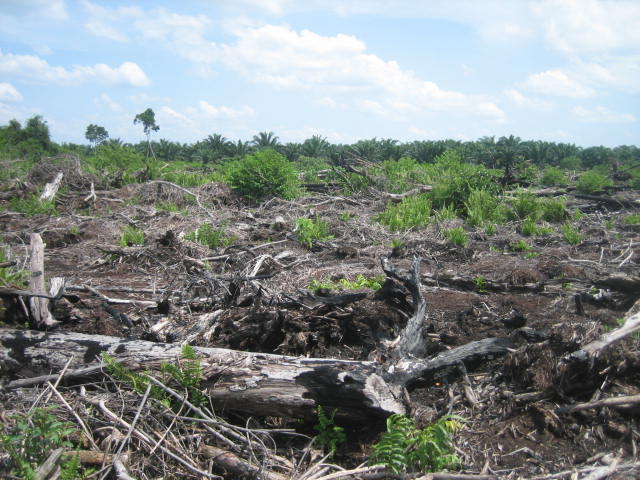
What is so special about peat?  To the untrained eye, these ecosystems appear as desolate swamps, with limited value, biodiversity- or other-wise.  To the seasoned wetland ecologist, the more apt question is what isn’t special about peat?  These long-neglected ecosystems are vital reservoirs of fresh water for us thirsty humans; they contain ten times as much carbon as all of the world’s forests, whilst occupying only 3% of the Earth’s surface; and house a rich diversity of species found nowhere else.  Yet as we begin to learn more about the world’s peatlands, we master the technologies needed to exploit them rapidly and irreversibly (Fig. 1).

IMG_2363

Fig. 1      A drained peatland in Indonesian Borneo, with young oil palm plants in the foreground and heavily degraded peat swamp forest in the background.

To be scientifically accurate, the irreversible component of peatland conversion is an assumption, wanting of sufficient evidence from “the field” due to the recent nature of large-scale exploitation.  But any ecosystem we see today is a product of its evolving past; a period over which it has encountered disturbances and presented a response.  From these patterns of responses, we can measure the resilience of the ecosystem (Cole et al., 2014) and develop hypotheses as to how it may respond to future disturbances.  In its simplest form, resilience is described as the ability of an ecosystem to maintain its structure and function despite perturbation (Holling, 1973).

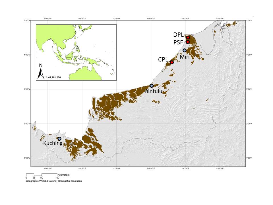
How resilient are peatlands?  Specifically, how have the tropical peat swamp forests of Southeast Asia responded to disturbance in the past?  We sought to answer these questions for the coastal peatlands of Sarawak, in Malaysian Borneo (Cole et al., 2015) (Fig. 2).

The plug is rapidly being pulled on these sweaty, mosquito-ridden jungles as industrial-scale agriculture spreads like wildfire across the region.  Dipterocarp forests, rich in a variety of fruit-bearing trees, ‘black-water’-adapted fish and nimble mammals, are being drained, flattened and converted into monoculture landscapes where oil palms (Elaeis guineensis) can quickly bring economic profit to even the inexperienced farmer.  Though wild-fires themselves are in fact a rare phenomenon in intact peatlands, the recent elevation in burning has been blamed primarily on the recent expansion of agriculture, and brought huge environmental, health and political challenges to the region.  But how frequent were fires in the past?  And what impact did they have on the vegetation?

Unlike in the temperate zone, tropical peat swamps are naturally forested.  It is the pollen grains and fern spores produced by this vegetation that provide the answers to our questions and insights into the resilience of these ecosystems.  Fossilised grains, deposited tens to millions of years in the past, are one of the primary datasets available in palaeoecology.  Often referred to as (the less archaic-sounding) long-term ecology, the discipline extends the scope of ‘short-term’ ecology through using deposited remains to study plants and animals and their interactions with the environments of the past.

We used pollen grains, fern spores and fossil charcoal to explore drivers and impacts of disturbance in three peatland areas in northern Borneo.  Peat cores were collected from three coastal sites in Sarawak (Fig. 2), where peat extends over approximately 13% of the States’ land surface.  The depths of the cores ranged from c. 1.5 to 3m, and radiocarbon dating of sediment samples from each demonstrated that they covered a period of 2000 to 7000 years before present (BP).

Sarawak_peatlands_map_division_labels_revised_JoE

Fig. 2      The three degraded peatland sites (red circles; DPL, PSF & CPL) from which cores were collected for this palaeoecological study, in Sarawak, Malaysian Borneo.  Sarawak’s peatlands are shown in brown and its major towns in blue.

Once I’d spent many more hours than I’d like to remember counting and identifying microscopic pollen grains, I was able to look for answers to our key research questions:

  • How has the vegetation in these peatland ecosystems changed through time?
  • What factors disturbed the peat swamp forest vegetation?
  • How did these ecosystems respond to the different disturbances?

Vegetation change

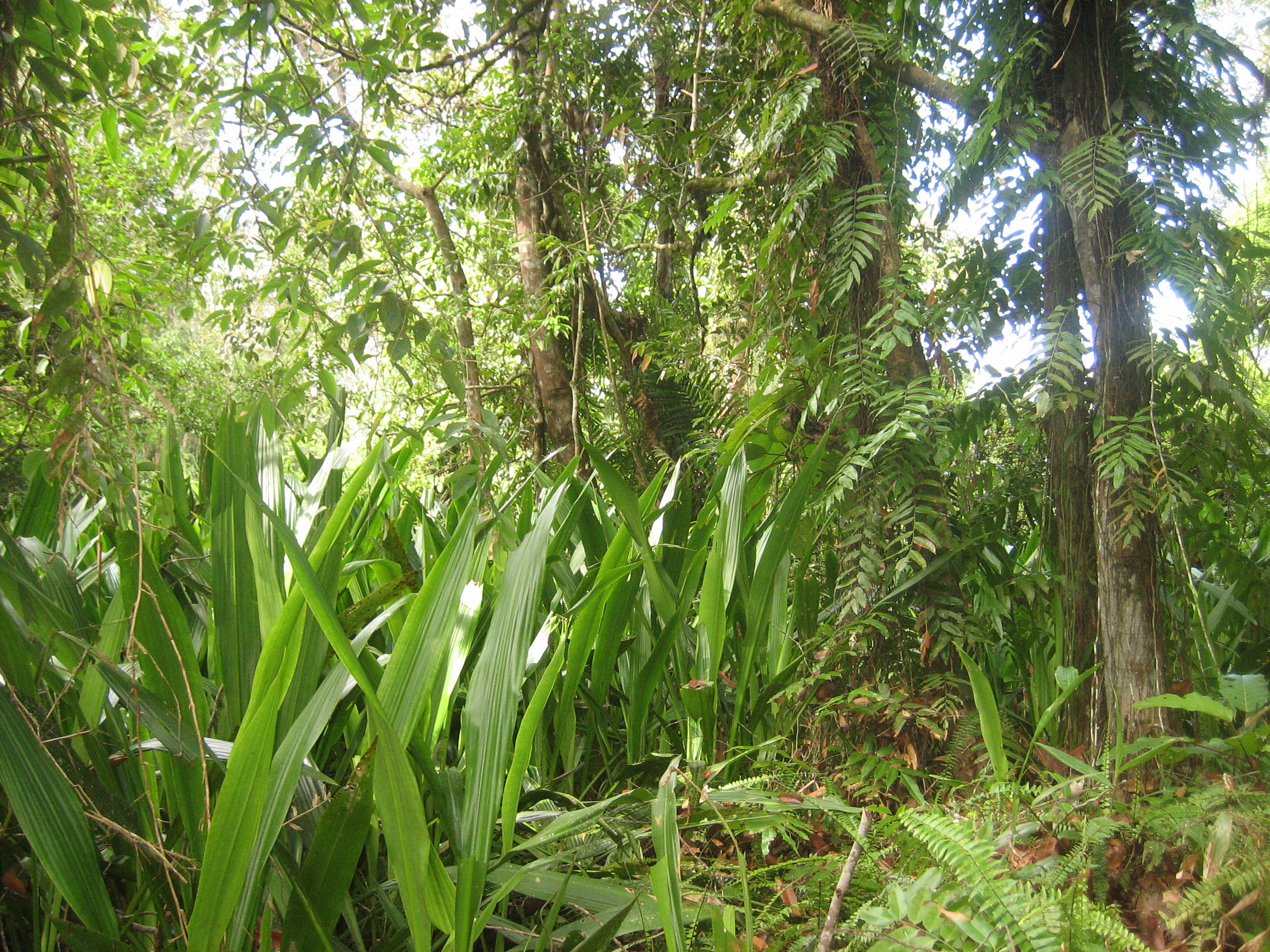
Our data demonstrated that peat swamp forest vegetation has persisted in these coastal peatlands since the onset of ecosystem development c. 4000yrs BP.  At this time, coastal progradation, resulting from sea-level fall, provided land suitable for peat to accumulate.  Apart from fluctuations between pioneer and mature peat swamp forest species over this period, reflecting local disturbances and dynamic internal responses (Fig. 3), the only significant vegetation change observed was shown in the last 500 years in two of the cores.  Increases in plant taxa associated with degraded peatlands suggested the introduction of humans and land use change to these coastal ecosystems.

PSF2-N_from_coring_site

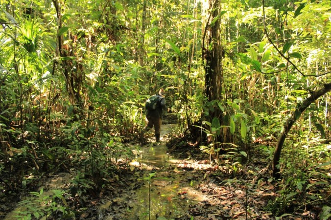
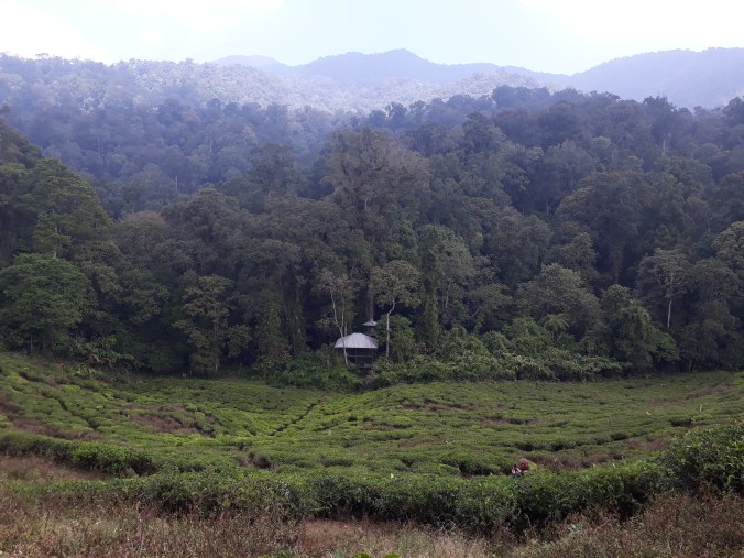
Fig. 3      Relatively intact peat swamp forest patch, near to the site where the “PSF” core was extracted (Fig. 2).

Disturbances

There were three drivers of vegetation change that we focused on in this study, each with its associated palaeoecological proxy: climatic variability, such as El Niño Southern Oscillation (ENSO) activity, identified through a literature review; local and regional fire inferred from fossil macro- and microcharcoal respectively, and anthropogenic activity indicated by pollen and spores of plants common in open areas, such as grasses (Poaceae) and sedges (Cyperaceae).  The literature reported increasing intensity of ENSO events in this region over the late Holocene, subjecting northern Borneo to arid conditions.  Burning, both from local and regional fires, occurred throughout the past in all three sites, though elevated dramatically in the last c. 500 years in parallel with greater levels of open vegetation indicators.

Vegetation response

Only within the recent past, from c. 200-500 years BP, did the peat swamp forest vegetation show signs of being ‘disturbed’.  Prior to this period, episodes of more intense ENSO and burning did not appear to correspond with notable declines in the peat swamp forest taxa, suggesting ecosystem resilience to these forms of perturbation.  However, given that elevated levels of open vegetation indicators and charcoal do correlate with the declines observed in the recent past, and in the period when literature and interviews suggest humans started exploiting these environments, it is likely that anthropogenic activities are responsible.  Though a lack of sufficient data prevents us from inferring whether these changes equate to a recent loss of ecosystem resilience, we have made several conclusions:

  • These peat swamp forests have shown resilience to natural disturbances in the past;
  • Levels of disturbance within the last c. 500 years have exceeded those recorded in the previous 5000 years, and humans are the main culprits;
  • Recent, coincident instability and declines in peat swamp forest taxa suggest a notable anthropogenic impact on this ecosystem, potentially challenging the future persistence of these forests.

Back to the future

So, what more do we need to know about these vital* ecosystems?  Our study has provided some baseline data and information on the functioning of the coastal peat swamp forests of northern Borneo, but there are many other patches of peat around the island, and indeed the whole region to investigate.  In order to design more sustainable management practices for these unique ecosystems, it is important that we find out more about their ecology, past and present, and in particular their ability to respond to different disturbances.  With fire posing a major threat to the persistence of Southeast Asian peatlands, and the resultant carbon emissions posing a major threat to us, we need to gather insights from patterns of past recovery and build an understanding of peat swamp forest resilience.  And fast, before there’s no mud left.

*I hope I have convinced you of their extreme importance by now!


References

Cole, L.E.S., Bhagwat, S.A. & Willis, K.J. (2014) Recovery and resilience of tropical forests after disturbance. Nature Communications, 5:3906, 1-7. Doi: 10.1038/ncomms4906.

Cole, L.E.S., Bhagwat, S.A. & Willis, K.J. (2015) Long-term disturbance dynamics and resilience of tropical peat swamp forests. Journal of Ecology – Special Issue on Forest Resilience. Doi: 10.1111/1365-2745.12329.

Gaveau et al. (2014) Major atmospheric emissions from peat fires in Southeast Asia during non-drought years: evidence from the 2013 Sumatran fires. Nature, 4:6112. Doi: 10.1038/srep06112.

Holling, C.S. (1973) Resilience and stability of ecological systems. Annual Review of Ecology and Systematics, 4, 1–23.

Page, S.E., Siegert, F., Rieley, J.O., Boehm, H.-D.V., Jaya, A. & Limin, S. (2002) The amount of carbon released from peat and forest fires in Indonesia during 1997. Nature, 420, 61–65.